Strange spikes in my OR Route project

Use this forum if you need help using TSRE.
User avatar
VAPOR3D
Posts: 13
Joined: 31 May 2020, 02:30
Hello!

Garry, sorry I'm late. I've been busy with other things for several days now.

There really are many, in various points and directions. If I deactivate the Distant Mountains they will disappear, but I hope the image will work!
Open Rails 2020-09-08 12-35-19.png
Open Rails 2020-09-08 12-35-19.png (1.21 MiB) Viewed 8919 times

Garry
Posts: 31
Joined: 16 Jan 2019, 16:12
This is strange!
Unfortunately I am not able to post screenshots at the moment, UKTrainsim is under a major repair.
I have gone to the location shown on your picture. Both Google Earth and my route place this high on the mountain side, 2370m, to the south west of Nuria.
Looking at 30 degrees as you are, I see no spikes, and I have both standard and distant terrain in this direction until I reach latitude 43 degrees, I have not downloaded the height files here.

Is it possible for you to post on your website, your copies of the terrain folders --- tiles ---- lo_tiles. Then I can have another look.

For your information I generated all my terrain using the .hgt files from your link, and then using TSRE.

Garry

User avatar
Switch Tender
Posts: 37
Joined: 17 Jan 2019, 01:58
I ran into this while working on some tiles in Northeast Kansas.
spikes2.JPG
spikes2.JPG (47.83 KiB) Viewed 8896 times
Took a closer look at the hgt file and saw this.
Hgt.JPG
Hgt.JPG (27.48 KiB) Viewed 8896 times
Looks like it ran off of the film sprocket.
Easy enough to fix.

Randy

User avatar
VAPOR3D
Posts: 13
Joined: 31 May 2020, 02:30
Garry wrote: 09 Sep 2020, 15:33 This is strange!
Unfortunately I am not able to post screenshots at the moment, UKTrainsim is under a major repair.
I have gone to the location shown on your picture. Both Google Earth and my route place this high on the mountain side, 2370m, to the south west of Nuria.
Looking at 30 degrees as you are, I see no spikes, and I have both standard and distant terrain in this direction until I reach latitude 43 degrees, I have not downloaded the height files here.

Is it possible for you to post on your website, your copies of the terrain folders --- tiles ---- lo_tiles. Then I can have another look.

For your information I generated all my terrain using the .hgt files from your link, and then using TSRE.

Garry
Hello!

Thank you very much!

So, one possibility is that it's a matter of my graphics card.

Another thing I can think of is that you send me via, for example, MEGA or Wetransfer your files corresponding to the distant mountains from that area.

Because maybe the problem is also the generation of my distant mountains via DEMEX in "Unregistered" or "Demo" mode, I don't remember it now...

Greetings!

Garry
Posts: 31
Joined: 16 Jan 2019, 16:12
I hope I have attached my Tiles and LoTiles folders, and also an OpenRails screenshot from a similar position to your previous image.
Spike.jpg
Spike.jpg (104.51 KiB) Viewed 8866 times
All the height files were generated using TSRE

Garry

User avatar
VAPOR3D
Posts: 13
Joined: 31 May 2020, 02:30
Hello!

Thank you very much Garrry, I downloaded the files and replaced them with the ones with the same name, although there are many more in my folder.

The result is the same as before.

It is possible that the problem is in one of the previous files. I don't know whether to try deleting them all and putting only these of yours, Garry.

Right now the look with the new files is this:
Open Rails 2020-09-13 07-06-18.png
Open Rails 2020-09-13 07-06-18.png (1 MiB) Viewed 8833 times
The work I had already done has been lost, but it would be useless to continue anything without first solving this.

User avatar
VAPOR3D
Posts: 13
Joined: 31 May 2020, 02:30
Well, I got a breakthrough.

1.I have deleted all the contents of the TILES and LO_TILES folders.

2.I have opened the Path with TSRE and I have generated the terrain.

3.I have copied Garry's files into the respective folders.

Now I have opened the Path with OR and Bingo! the spikes have disappeared:

Open Rails 2020-09-13 07-32-02.png
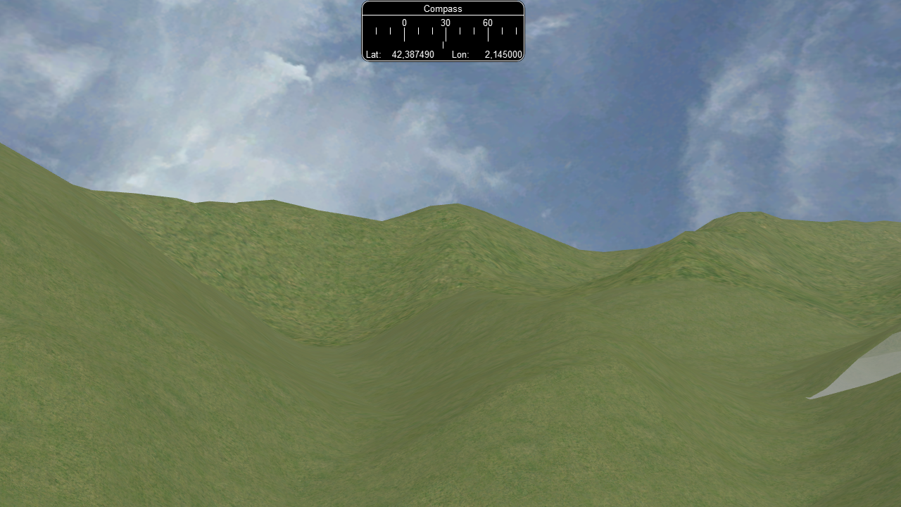
Open Rails 2020-09-13 07-32-02.png (1.07 MiB) Viewed 8832 times
In the image, at right, there are other new problems with the terrain, which we hope will be possible to solve. I have lost all the modifications of the terrain, but at least I will be able to start everything again in good conditions. It is clear that the problem was some old files coming, for sure, from the time when it was necessary to use DEMEX to generate the distant mountains.

Thank you very much for your help. Anything, here I am!

Garry
Posts: 31
Joined: 16 Jan 2019, 16:12
I am pleased that things are going well. The white gap in your image is probably caused by the tile for that region not having been generated. This is the reason that you can see below ground level in this image from my Swiss route. You will also notice that I have underground spikes, which cause problems only when they are close to the track. They are easy to remove, just place a track or road section beside it, rotate it until it projects over the dip (or into the spike). Press F to get the ground to track level. You may have to repeat this around the problem area until it is all level.
Spike02.jpg
Spike02.jpg (51.24 KiB) Viewed 8814 times
I notice that your route is a rack railway. Can I ask how you are going to get the trains to run up the steep gradient. I build a route from Lucerne to Engelberg which in reality is a rack railway. I cheated and used RouteRiter to decrease the height of the area around Engelberg.

Garry

Post Reply